SMC weather warnings#
The Servei Meteorològic de Catalunya (SMC) issues warnings on the forecast of various dangerous situations (Situacions Meteorològiques de Perill - SMP).
A team of experts, based on forecasts from numerical weather forecasting models and data observed through various instruments, interprets the situation and issues warnings for different meteorological phenomena based on their “rarity” and potential impact.
These warnings can be of:
Forecast. A dangerous weather situation is foreseen.
Observation. A phenomenon that had not been foreseen or had been foreseen to a lesser degree is observed and its evolution is foreseen.
The Meteorological Hazard Situation is classified according to the hazard degree which has a scale from 0 to 6 and is grouped in a 4-colour traffic light code.

The degree is determined according to the relationship between the threshold that can be exceeded and the probability of occurrence of the meteorological phenomenon in the territory, according to the following matrix:

The probability is divided into the following ranges:
High probability: above 70%.
Medium probability: between 30% and 70%.
Low probability: between 10% and 30%.
On the other hand, the forecast for the different meteorological phenomena is made by administrative counties for the next 3 days in 4 periods of 6 hours for each day:
00h to 06h UTC (Official summer time: 02h to 08h CEST. Official winter time: 01h to 07h CET).
06h to 12h UTC (Official summer time: 08h to 14h CEST. Official winter time: 07h to 13h CET).
12h to 18h UTC (Official summer time: 14h to 20h CEST. Official winter time: 13h to 19h CET).
18h to 24h UTC (Official summer time: 20h to 02h CEST. Official winter time: 19h to 01h CET).
Temporal resolution#
The temporal resolution varies according to the type of warning:
Forecast warnings. Provides a 3-day forecast, with a 6-hour time step.
Severe weather warnings. Provides a very short term warning of between 30 minutes to 2 hours of forecast.
Observation warnings. Provides the current state of affectation.
Update frequency#
Data is updated in real time.
Available warning types#
The following warning types are available on the platform:
Rain accumulation warning#
The specific thresholds are:
Low threshold: Accumulated > 100 mm / 24 hours
High threshold: Accumulation > 200 mm / 24 hours
Rain intensity warning#
The specific thresholds are:
Low threshold: Intensity > 20 mm / 30 min.
High threshold: Intensity > 40 mm / 30 minutes
Sea status warning#
The specific thresholds are:
Low threshold: Waves > 2,50 m
High threshold: Waves > 4 m
Snow accumulation warning#
The specific thresholds are:
- Low threshold
Thickness ≥ 0 cm at elevations below 300 m
Thickness > 2 cm at elevations above 300 m up to 600 m
Thickness > 5 cm at elevations above 600 m up to 800 m
Thickness > 10 cm at altitudes above 800 m up to 1.000 m
Thickness > 20 cm at altitudes above 1,000 m up to 1,500 m
- High threshold
Thickness > 5 cm at altitudes below 300 m
Thickness > 15 cm at altitudes above 300 m to 600 m
Thickness > 20 cm at altitudes above 600 m to 800 m
Thickness > 30 cm at altitudes above 800 m up to 1.000 m
Thickness > 50 cm at altitudes above 1,000 m up to 1,500 m
Wind gust warning#
The specific thresholds vary according to the county:
- Low threshold
Maximum gust > 20 m/s (72 km/h) to: Anoia, Alt Penedès, Bages, Baix Llobregat, Baix Penedès, Barcelonès, Garraf, Gironès, Maresme, Moianès, Osona, Pla d’Urgell, Segarra, Segrià, Selva, Tarragonès, Urgell, Vallès Occidental and Vallès Oriental.
Maximum gust > 25 m/s (90 km/h) at: Alt Camp, Alt Urgell, Alta Ribagorça, Baix Camp, Baix Empordà, Berguedà, Cerdanya, Conca de Barberà, Garrigues, Garrotxa, Noguera, Pallars Jussà, Pallars Sobirà, Pla de l’Estany, Priorat, Ribera d’Ebre, Ripollès, Solsonès, Terra Alta and Val d’Aran.
Maximum gust > 30 m/s (108 km/h) at: Alt Empordà, Baix Ebre and Montsià.
- High threshold
Maximum gust > 30 m/s (108 km/h) at: Anoia, Alt Penedès, Bages, Baix Llobregat, Baix Penedès, Barcelonès, Garraf, Gironès, Maresme, Moianès, Osona, Pla d’Urgell, Segarra, Segrià, Selva, Tarragonès, Urgell, Vallès Occidental and Vallès Oriental.
Maximum gust > 35 m/s (126 km/h) at: Alt Camp, Alt Urgell, Alta Ribagorça, Baix Camp, Baix Empordà, Berguedà, Cerdanya, Conca de Barberà, Garrigues, Garrotxa, Noguera, Pallars Jussà, Pallars Sobirà, Pla de l’Estany, Priorat, Ribera d’Ebre, Ripollès, Solsonès, Terra Alta and Val d’Aran.
Maximum gust > 40 m/s (144 km/h) at: Alt Empordà, Baix Ebre and Montsià.
Minimum temperature warning#
The specific thresholds vary according to the county:
Low threshold: Temperature below the 2nd percentile of the daily minimum temperature (extreme minimum temperature).
High threshold: Temperature below the 2nd percentile of the daily minimum temperature for three or more consecutive days (cold snap).
Maximum temperature warning#
The specific thresholds vary according to the county:
Low threshold: Temperature above the 98th percentile of the daily maximum temperature (extreme maximum temperature).
High threshold: Temperature above the 98th percentile of the daily maximum temperature for three or more consecutive days (heat wave).
Severe Weather Warning#
A Severe Weather Warning is issued when the possibility of the occurrence of a convective weather phenomenon that may cause property damage or endanger life is foreseen.
Severe weather is defined as stones larger than 2 cm in diameter, wind gusts of more than 90 km/h (25 m/s) associated with thunderstorms, squalls, tornadoes or gusts.
These warnings, which are valid for up to two hours from the time of issuance, are based on the observation of a sudden increase in thunderstorms, called a Lightning Jump (LJ). When this increase in lightning is detected, and consequently the LJ occurs, there is a certain probability that, in the places where the storm passes, some of the phenomena defined as violent weather will be recorded.
Visualization#
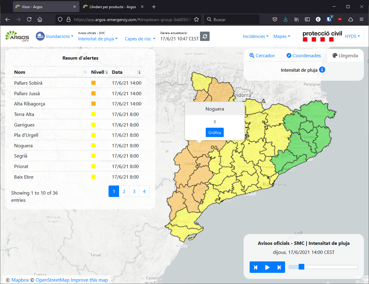
The current status of the warnings is displayed. Clicking on the area provides additional information and also an evolution graph.

Useful links#
Data sources#
Obtained through the open data portal portal.