Fire Risk (RISICO)#
Since 2000, Liguria Region and the Italian Civil Protection carried out independent research programs that led to the creation of RISICO, a fire danger rating system adapted to the vegetation cover of the Mediterranean (Fiorucci et al., 2011). Developed by the CIMA fundation, RISICO integrates meteorological observations and forecasts provided by a Numerical Weather Prediction (NWP) model with vegetation cover and topography as additional inputs to the system. It allows to discriminate the behavior of fire among different fuels types taking into account the effect of slope on fire behavior, including important aspects related with the process of fire spread beyond the weather.
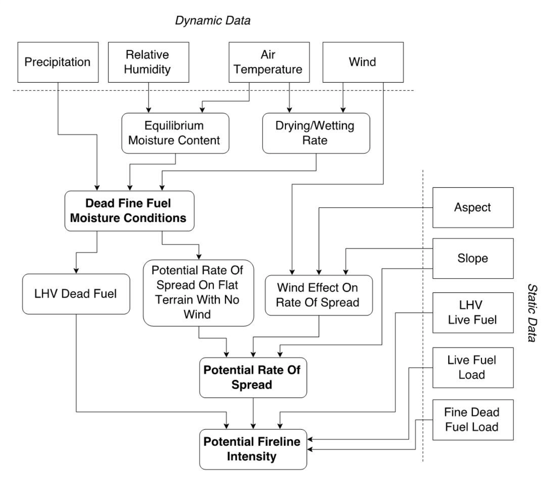
The general structure of the RISICO system is represented in the following figure.

The information feeding the various modules is partly static and partly dynamic. The static information is the topography and some parameters related to the vegetation cover. Regarding the topography, a Digital Elevation Model (DEM) is used in order to represent the aspect and the slope of the area. Vegetation cover can be provided by CLC (CORINE Land Cover) map or a different Land Use – Land Cover map. The vegetation classes defined in the available map are aggregated in 7 fuel types. For each fuel type a set of parameters have been defined in order to discriminate the main fire behaviours.
Concerning dynamic data, the RISICO system needs in input meteorological fields which can be provided interpolating observation coming from a meteorological network (optional) or by the outputs of NWP models. RISICO is able to make use of the output of several NWP models with different spatial and temporal resolution. The reliability of the fire danger provided is dependent by the reliability of the meteorological input. The following Table 44 lists all the inputs required by the model.
Available variables#
The following variables are available on the platform:
Fireline Intensity#
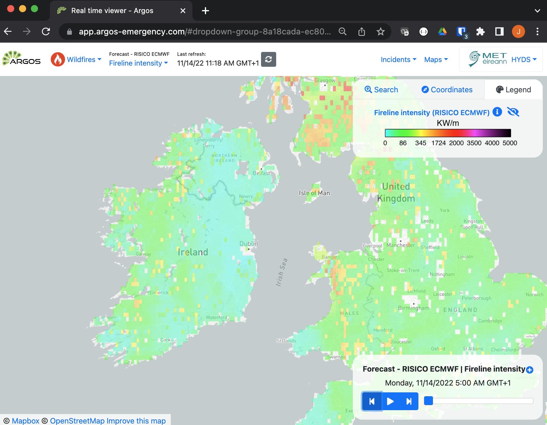
The Fireline Intensity is a measure of the rate at which heat is released by a wildfire as it spreads. It is an important output product of the RISICO model as it can be used to estimate the potential impact of a wildfire on the surrounding vegetation, structures, and other resources.
Fine Fuel Moisture Content#
Fine Fuel Moisture Content is a measure of the amount of moisture in small, easily ignitable fuels such as grasses, leaves, and twigs. It affects the rate of fire spread and the intensity of the fire.
Rate Of Spread#
The rate of spread is a measure of the speed at which a wildfire is likely to spread. It can be used to assess the potential speed and direction of a wildfire, which can inform fire management decisions.
Wind effect#
The Wind Effect is a multiplicative factor applied to the potential Rate of Spread on flat terrain in no wind condition (static input parameter) which consider the effect of wind speed on the Rate of Spread.
Risk level#
The Risk level is a derived product that is calculated by aggregating the values of the Rate of Spread product and is used to identify areas where fire risk exceeds certain thresholds. These areas can be defined at various geographic scales, such as counties or municipalities.
There are two different Risk Level products available, each of which applies a different calculation method to generate the output product:
Risk level. This product calculates the average value of all the RoS values within each area at hourly time intervals.
Daily risk level. This product calculates the average value of only those RoS values that are above the 75th percentile within each area at daily time intervals.
Temporal resolution#
The platform shows 90 hours of forecast in 1 hour intervals when using ECMWF forecasts, and 60 hours of forecast also in 1 hour intervals using Harmonie forecasts.
Update frequency#
Forecasts are updated every 6h for both cases (Harmonie and ECMWF models).
Visualization#

Useful links#
RISICO (Italian acronym for RISchio Incendi e COordinamento that means Fire Risk and Coordination)
References#
Fiorucci P., D’Andrea M., Negro D., Severino M. (a cura di), 2011, Manuale d’uso del sistema previsionale della pericolosità potenziale degli incendi boschivi RIS.I.CO., Presidenza del Consiglio dei Ministri – Dipartimento della protezione civile e Fondazione CIMA.
Fiorucci P., F. Gaetani, and R. Minciardi, 2008: Development and application of a system for dynamic wildfire risk assessment in Italy. Environmental Modelling & Software.
Fiorucci, P., F. Gaetani, A. Lanorte, and R. Lasaponara, 2007: Dynamic Fire Danger Mapping from Satellite Imagery and Meteorological Forecast Data. Earth Interactions, 11, 1–17.