AEMET weather warnings#
The Agencia Estatal de Meteorología (AEMET) issues warnings about adverse weather phenomena that may affect Spain in accordance with the National Plan for the Forecast and Monitoring of Adverse Weather Phenomena (Meteoalerta).
Adverse weather phenomena are considered to be any atmospheric event capable of directly or indirectly causing damage to people or significant material damage. In a less restricted sense, it can also be considered as such any phenomenon capable of significantly altering human activity in a given spatial area.
The warnings have been defined taking into account both the frequency of each phenomenon (the less frequent it is, the less prepared the population is) and the adversity (for that population). Accordingly, there are four basic levels:
Green: No meteorological risk exists.
Yellow: There is no meteorological risk for the population in general, although there is a risk for a specific activity (usual meteorological phenomena, but potentially dangerous).
Orange: There is a significant weather risk (unusual weather phenomena with some degree of danger for usual activities).
Red: The weather risk is extreme (unusual weather events of exceptional intensity and with a very high level of risk to the population).
The warnings detail, among other data, the areas in each province affected by the corresponding phenomenon together with the expected start and end times.
Temporal resolution#
The warnings provide a 3-day forecast, with a time step of 1 hour.
Update frequency#
Data is updated in real time.
Available warning types#
The following warning types are available on the platform:
1-hour rain accumulation warning#
The specific thresholds for this type of warning vary according to the region. (Thresholds and warning levels).
Below is a summary by region of the thresholds for YELLOW, ORANGE and RED levels:
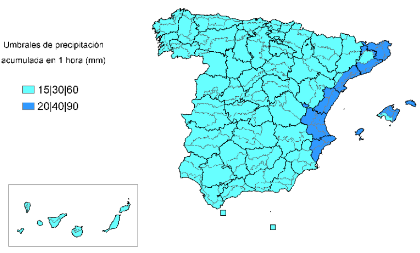
Rain accumulation thresholds. Credits: aemet.es#
12-hour rain accumulation warning#
The specific thresholds for this type of warning vary according to the region. (Thresholds and warning levels).
Below is a summary by region of the thresholds for YELLOW, ORANGE and RED levels:
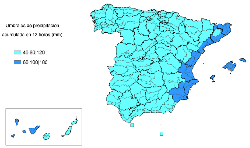
Rain accumulation thresholds. Credits: aemet.es#
Storm warning#
The specific thresholds for this type of warning are:
YELLOW LEVEL: Widespread thunderstorms with the possibility of the development of organised structures. Locally heavy rain and/or locally strong winds and/or hail of less than 2 cm. Given the nature of these phenomena, there is the possibility of occasional storms of higher intensity.
ORANGE LEVEL: Very organised and widespread thunderstorms. It is possible that locally very heavy rain and/or locally very strong winds and/or hail larger than 2 cm may occur. Tornadoes are also possible.
RED LEVEL: Highly organized storms. The probability of locally heavy rain and/or locally very strong winds and/or hail larger than 2 cm is very high. Tornadoes are likely.
Sea status warning#
The specific thresholds for this type of warning vary according to the region:
- YELLOW LEVEL
Cantabrian and Atlantic areas: F7, combined or compound seas causing waves of 4 to 5 metres.
Mediterranean areas: F7, combined or compound seas causing swell of 3 to 4 metres.
- ORANGE LEVEL**:
Cantabrian and Atlantic areas: F8 and F9, combined or compound seas causing waves of 5 to 8 metres.
Mediterranean areas: F8 and F9, combined or compound seas causing swell of 4 to 7 metres.
- RED LEVEL**:
Cantabrian and Atlantic areas: F10 and above, combined or compound seas causing swell of more than 8 metres.
Mediterranean areas: From F10 onwards, combined or compound seas causing swell of more than 7 metres.
Wind gust warning#
The specific thresholds for this type of warning vary according to the region. (Thresholds and warning levels).
Below is a summary by region of the thresholds for YELLOW, ORANGE and RED levels:
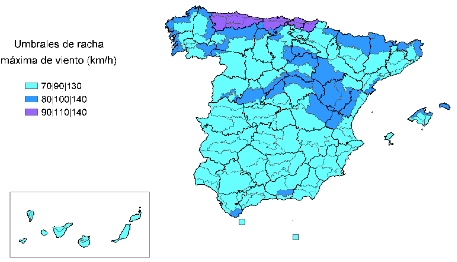
Wind gust thresholds. Credits: aemet.es#
24-hour snowfall accumulation warning#
The specific thresholds for this type of warning vary according to the region. (Thresholds and warning levels).
Below is a summary by region of the thresholds for YELLOW, ORANGE and RED levels:
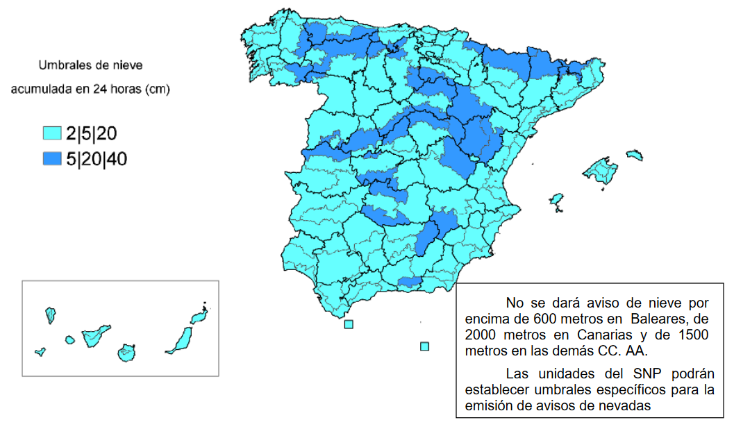
Thresholds of accumulated snow in 24 hours. Credits: aemet.es#
Minimum temperature warning#
The specific thresholds for this type of warning vary according to the region. (Thresholds and warning levels).
Below is a summary by region of the thresholds for YELLOW, ORANGE and RED levels:
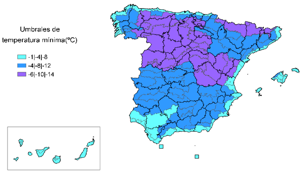
Minimum temperature thresholds. Credits: aemet.es#
Maximum temperature warning#
The specific thresholds for this type of warning vary according to the region. (Thresholds and warning levels).
Below is a summary by region of the thresholds for YELLOW, ORANGE and RED levels:
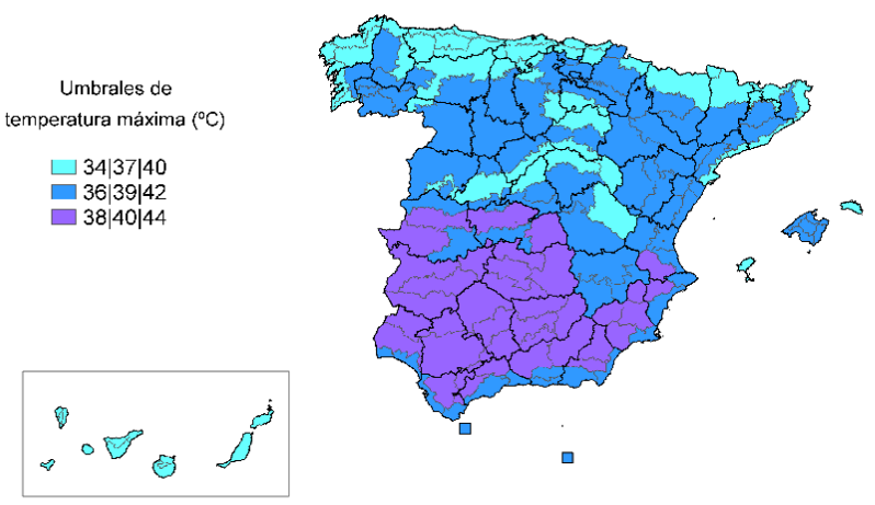
Maximum temperature thresholds. Credits: aemet.es#
Visualization#
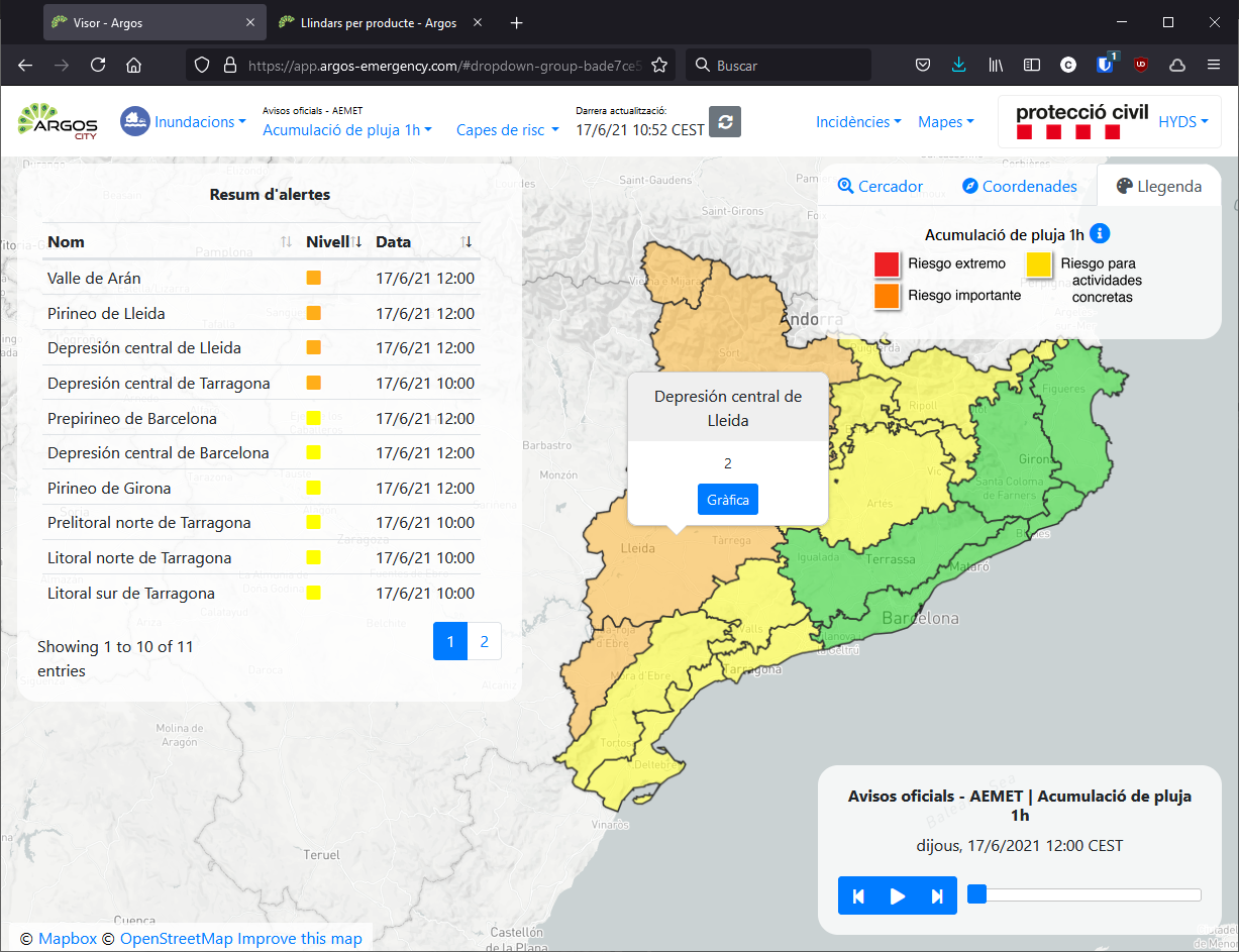
The current status of the warnings is displayed. Clicking on the area provides additional information and also an evolution graph.
Useful links#
Data sources#
Obtained through the open data portal portal.