Snow forecast on the road (CRAHI)#
The Centre de Recerca Aplicada en Hidrometeorologia (CRAHI) generates forecasts of the impact of snow on the roads.
The model is an adaptation of the RoadSurf model used by the Finnish Meteorological Institute (FMI) and the METRo model used by the Canadian Meteorological Center (CMC).
The model estimates the snow accumulation on the road surface at each node of the road, and summarises the results into road stretches with similar characteristics.
In essence, the model applies at local scale various equations that lead to snow accumulation in the road, modelling the heat flux in the down layers next to the road surface, acting as a heat storage. Adding the influence of the atmosphere close to the surface, this allows to quantify the amount of accumulated water on the road and its phase (permitting phase changes from snow-ice to liquid and viceversa), and to estimate the amount of water that is evaporated.
It is organised applying 3 modules related to the next 3 main processes:
Precipitation (snowfall or rainfall) resulting in the accumulation of water on the surface of the road.
Energy balance between the road surface and atmosphere.
Heat transfer from the lower ground layers of the road to the road surface. The ground is discretized in several layers and the heat diffusion equation is applied and solved using a finite difference scheme.
The energy balance is modelled as the sum of the most relevant energy flux terms:
q0 = qSW + qLW + qH + qLE + qCF + qTR + qPREP
where
qSW : energy flux from solar radiation
qLW : energy flux from long-wave radiation
qH : energy flux from sensible heat
qLE : energy flux from latent heat
qCF : energy flux due to the phase change of the water accumulated on the road surface
qTR : energy flux due to traffic vehicles activity
qPREP : energy flux due to precipitation
Several empiric equations are used to estimate the various energy flux terms. All the static parameters of the model were taken from the recommended values that are used in the reference models and related publications (RoadSurf and METRo).
When modelling the heat transfer from the road surface to the terrain, 15 layers have been considered, with a maximum depth of 2.80 m. These layers are thin next to the surface and thicker below. The first 6 layers are considered to be asphalt (up to a total depth of 0.22 m) and the remainder are considered to be granular soil, imposing different parameters related to the thermal diffusivity.
The dynamic variables are taken from the outputs of the Numerical Weather Prediction model (in this case, ECMWF’s IFS), with a time resolution of 1h for the forecasts up to 3 days. In particular, the model uses the following variables:
Surface temperature
Dew point temperature
Surface wind (at 10 m)
Surface pressure
Surface solar radiation
Surface thermal radiation
Precipitation
Road stretches selection#
The model provides outputs over the main roads of the region/country. Roads are split into various stretches, each of them having several computation points inside. These stretches are relatively homogeneous. In particular, they have a maximum height difference of 200 m and a maximum length of 15 km. Nevertheless, many of the sections are a lot shorter than 15 km, due to the splitting of the original provided road information. Inside a road stretch, the distance between computation nodes is about 1000 m, and the sections have a minimum of 2 computations nodes.
The complete calculations are done on all the nodes of the road network. Then, at each time step (every 1 hour), results for the points inside a particular section are compared and the results and the most unfavorable outputs in terms of driving difficulty are assigned to this road stretch. Thus, this method considers each road section as a uniform unit, making the visualization and identification of warnings at regional scale simpler.
Temporal resolution#
The forecast provides data for the next 72 hours with an hourly time step.
Update frequency#
Data is updated every 6 hours with each new model run.
Variables available#
The following variables are available on the platform:
Traffic impact#
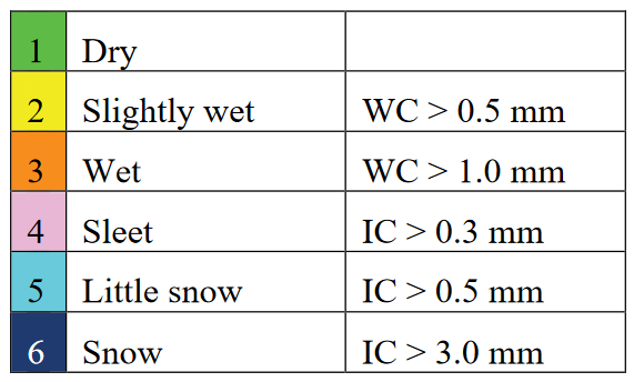
Represent the conditions used to establish the different levels of grip conditions of the road.

Where the abbreviations stand for:
WC: Liquid water accumulation on the road
IC: Ice accumulation on the road (expressed in terms of the equivalent liquid water content)
Road condition#
Represent the conditions used to establish the different levels of road weather conditions to describe the difficulty of driving. The level is achieved if either of the conditions is fulfilled.

Where the abbreviations stand for:
T: Temperature
WC: Liquid water accumulation on the road
IC: Ice accumulation on the road (expressed in terms of the equivalent liquid water content)
R: Rainfall rate; S: Snowfall rate (expressed in terms of the equivalent water content)
v: wind speed
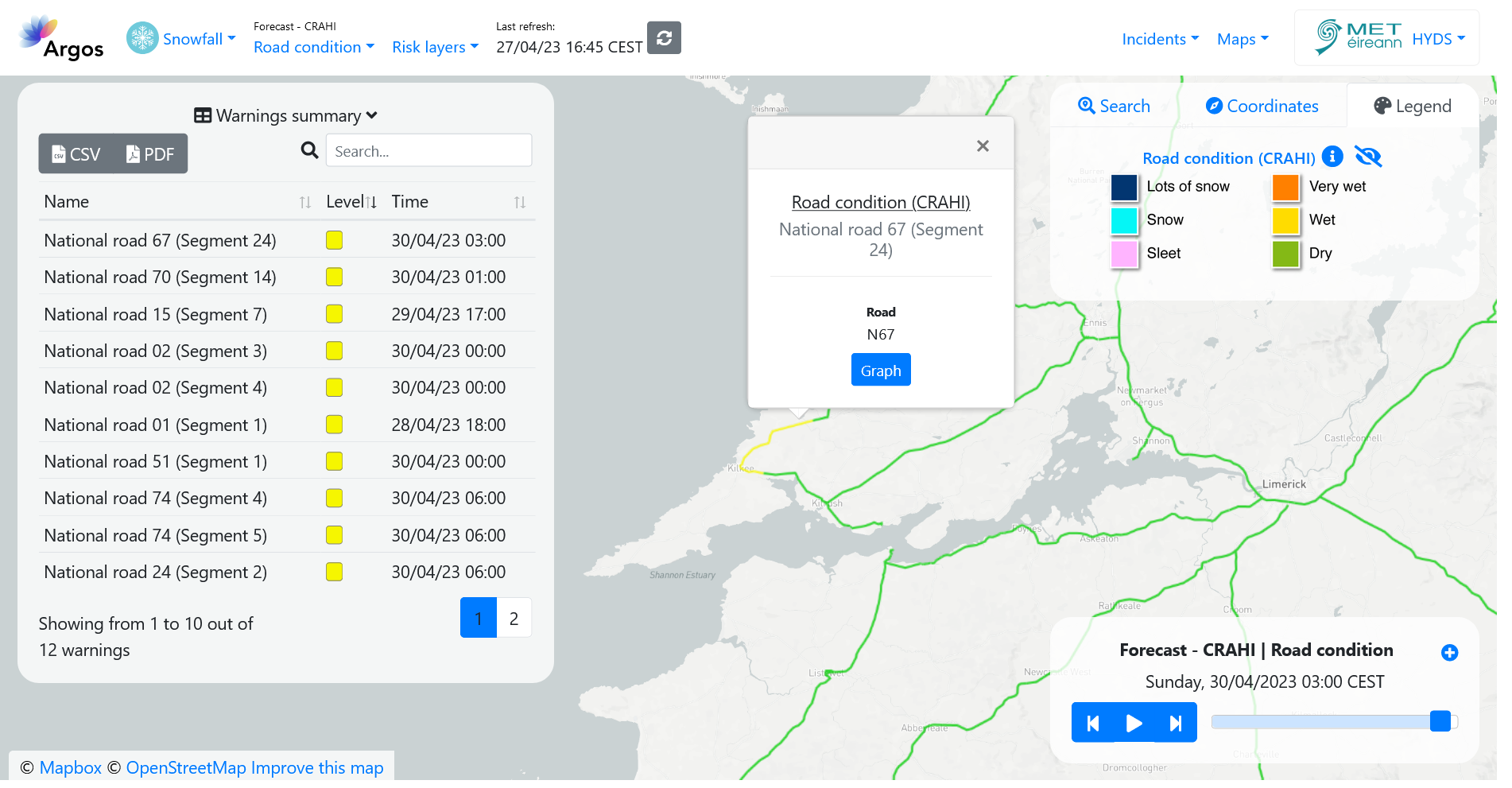
Visualization#

Useful links#
References#
Kangas, M., M. Heikinheimo, and M. Hippi, 2015: RoadSurf: a modelling system for predicting road weather and road surface conditions. Meteorol. Appl., 22, 544–553, doi:10.1002/met.1486. http://doi.wiley.com/10.1002/met.1486.
Crevier, L.-P., and Y. Delage, 2001: METRo: A New Model for Road-Condition Forecasting in Canada. Journal of Applied Meteorology, 40, 2026-2037. doi:10.1175/1520-0450(2001)040%3C2026:MANMFR%3E2.0.CO;2